CHAPTER I
ERODE DISTRICT - A PROFILE |
|
General Profile:
Erode district predominantly agrarian in nature, is emerging gradually but steadily as an Industrially Promising District. Erode was previously a part of Coimbatore District and it has been bifurcated from Coimbatore District on 17th September 1979 as a new district. Erode is known for the biggest textile shandy for marketing the powerloom and handloom products.
The district lies between 10.36' and 11.58' degrees of northern latitude and between 76.49' and 77.58' Degrees of the Eastern Longitude and 171.91 meters above mean sea level. It has an area of 8,162 sq.kms accounting for 6.3% of the total area of the state and is bounded by Karnataka State in the North, Udhagamandalam District in the North West, Coimbatore District in the West, Dindigul District in the South, Karur District in the South East and Namakkal, Salem districts in the East.
Administrative Profile
|
Total Geographical Area-8162sq.kms |
Revenue Division-3 | Taluks-7 |
Panchayat Unions -20 | Municipalities-5 | Townships-1 | Town Panchayats-59 |
|
|
The district has 3 Revenue Divisions and 7 Taluks. It has 20 blocks, 5 Municipalities, 1 Township, 59 town Panchayats and 343 Village Panchayats.
The climate of the district is comparatively hot throughout the year except during the North East monsoon period, October to December. The normal rain fall is 698.1 mm as against the state average of 946.9 mm. Actual rainfall in this district was 782.8 mm in against the state average of 11338 mm during 1997-98. Most of the places in this district are experiencing Northwest monsoon, however some places in Dharapuram and Sathyamangalam etc get sporadic rains during South-West monsoon.
The soil of the District is predominantly red sandy to red gravelly type in the taluks of Bhavani, Erode, Perundurai and Dharapuram. Red loamy soil occurs at the bottom of the valleys in the taluks of Gobichettipalayam and Sathyamanagalam.
TALUKS & BLOCKS IN ERODE DISTRICT
|
Sl.No | Name of the Taluk | Blocks included in the taluk |
| 1. | Erode. | 1.Erode
2.Modakurichi
3.Kodumudi |
| 2. | Perundurai. | 1.Perundurai
2.Chennimalai
3.Uthukuli |
| 3. | Kangayam. | 1.Kangayam
2.Vellakoil
3.Mulanur |
| 4. | Dharapuram. | 1.Dharapuram
2. Kundadam |
| 5. | Bhavani. | 1.Bhavani,
2.Anthiyur
3. Ammapet |
| 6. | Sathyamangalam . | 1.Sathyamangalam
2. Bhavanisagar
3. Thalavadi |
| 7. | Gobichettipalayam. | 1.Gobichettipalayam
2. Nambiyur
3.T.N.Palayam |
|
|
DEMOGRAPHIC PROFILE
The district has got a population of 23.20 lakhs accounting for 4.2% of the States population as per 1991 census against the share of 6.3% of the geographical area of the state. The population projected for the year 2000 is 25.06 lakhs.
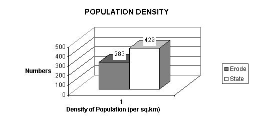
The rural population consists of 75.29% of the total population, as compared with state�s average of 65.85%. The density of the population is 283 per sq.km as against the state�s average of 429 per sq.km. SC population represents 17.16% of the total population and the ST population is found to be 0.42% of the district population as per 1991 census.
Demographic Profile of Erode District vis-a-vis the state.
|
| Attribute | Unit | Erode
District | Tamilnadu State |
| Population (1991 Census) | Lakh Nos. | 23.20 | 558.59 |
| Population Density(per sq km) | No. | 283 | 429 |
Decennial Population Growth
1981-91 | Percentage | 12.17 | 15.39 |
| Males as a % of population | " | 51.08 | 50.66 |
| Level of urbanisation (%) | � | 24.71 | 34.15 |
| Worker Participation Rates (%) | � | 52.30 | 43.31 |
| Literacy rate (%) | � | 48.13 | 62.66 |
| Female literacy rate | � | 37.27 | 44.58 |
|
Source: Department of Statistics, Erode, Government of Tamilnadu
|
 |
|
Decennal Growth
|
| Period | % Growth in
Population | % Growth in Rural
Population | % Growth in Urban
Population |
| | Erode | Tamilnadu | Erode | Tamilnadu | Erode | Tamilnadu |
| 1951-61 | 7.20 | 11.85 | 2.62 | 8.39 | 48.71 | 22.59 |
| 1961-71 | 20.40 | 22.30 | 14.21 | 16.35 | 59.14 | 38.64 |
| 1971-81 | 15.11 | 17.54 | 9.76 | 12.95 | 39.13 | 27.98 |
| 1981-91 | 12.17 | 15.39 | 8.29 | 13.32 | 25.94 | 19.59 |
|
Source: Dte. of Economics & Statistics, Government of Tamil Nadu.
Decennicl Growth during 1951 - 1991
|
 |
|
During 1961-71, the decennial growth rate was considerably increased due to improvement in health care and during 70's and 80�s there was a marginal decline in the population growth due to successful implementation of family planning scheme. During this period the growth rate is lesser than that of the state.
In the sector wise growth rate, rural population growth is lesser than the overall growth rate of the district as well as that of state. However urban population growth witnessed an all time high of 59.14% during the 60�s and 39.13% & 25.94% during the 70�s and 80�s. It is due to development of industries in the urban sector & migration of population to urban sector.
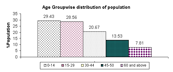
Following table shows the percentage of Population in different Age Groups (Projected for 1998)
Percentage of Population Age Group - wise
|
| Age Group | % Population in this group to
total population in Erode
District | % population in this group
to total population in
Tamilnadu |
| 0-14 | 29.43 | 34.77 |
| 15-29 | 28.56 | 27.08 |
| 30-44 | 20.67 | 19.16 |
| 45-50 | 13.53 | 12.48 |
| 60 and above | 7.81 | 6.51 |
|
|
|
 |
|
Source: Directorate of Economics & Statistics, Government of
Tamilnadu.
The potential workforce i.e. number of persons in the age group of 15-59 in this district is 62.76%, which is very much higher than the state percentage of 58.72%.
WORK FORCE:
The total workforce of the district is 12.14 lakhs (including marginal workers, of which, 11.52 lakhs are main workers) as against states level of 241.94 lakhs. It accounts for 52.30% of the total population of the district. Agriculture and allied activities constitutes the major source of employment with 59.68% of the total workforce. Secondary sector provides employment for 3.87% and the tertiary sector provides employment for 31.41% of the total workforce.
Labour Force - population by Broad Industrial Categories of workers
(as per 1991 Census)
|
| Sl.No | Industrial Category | Erode District | Tamil Nadu |
| | | Persons | % to total
workers | Persons | % to total
workers |
| 1 | 2 | 3 | 4 | 5 | 6 |
| 1 | Cultivators | 274235 | 22.59 | 5664090 | 23.41 |
| 2 | Agricultural Labours | 450036 | 37.09 | 7896295 | 32.64 |
| 3 | Household Industry,
Manufacturing, Processing
Servicing and Reports | 46944 | 3.87 | 802956 | 3.32 |
| 4 | Other workers | 381195 | 31.41 | 8435725 | 34.86 |
| 5 | Total main workers | 1152410 | 94.96 | 22799066 | 94.23 |
| 6 | Marginal workers | 61150 | 5.04 | 1395277 | 5.77 |
| 7 | Total workers | 1213560 | 100.00 | 24194343 | 100.00 |
| 8 | Non workers | 1106703 | - | 31664603 | - |
| 9 | Total Population | 2320263 | - | 55858946 | - |
|
|
ECONOMIC PROFILE
AGRICULTURE
Erode district has a strong agricultural base, which provides employment to 59.68% of the workforce. It plays an important role in the district economy. The total area brought under cultivation is 3.09 lakh hectares accounting for 37.89% of the total area. The total cropped area is 3.57 lakhs hectares, constituting 5.48% of the states total cropped area. Oil seeds are major crop followed by cereals cultivated here. Besides these sugarcane, turmeric, cotton are also cultivated. The cropping intensity is 1.15. Cultivable waste is 0.08% of the total geographical area of the district.
This district is having one Regional Agricultural Research Station of Tamilnadu Agricultural University at Bhavanisagar.
The agricultural activity in the district is well supported by the rivers Cauvery and Bhavani. Amaravathi river, Uppar and Parambikulam Aliyar Projects are the other sources of irrigation in this district. Actual rainfall in this district is 715.2 mm in 1999-2000. Northeast monsoon is the major contributor with 493.8 mm followed by south west monsoon.
INDUSTRY:
Erode district is one among the industrially developing districts. Industry and Trade occupy a place of prominence in the economy of the district. Industries that flourished in early days in and around Erode area were handloom weaving and carpet manufacturing. The advent of modern era has changed these industries to some extent and the powerloom weaving is slowly replacing it. There are 24189 registered SSI units as on 31.12.2000 in the district besides 59 Large Scale Units.
The district has high concentration of powerloom & Handloom weaving, Rice milling, Edible oil expelling units. The other industries are Tanneries, Chemical & Plastic Products, Paper Products, Basic Metal Products industries etc.
INFRASTRUCTURE:
Infrastructure is recognised as the most important factor as well as promoter of industrial activity in the economy. Availability of Power, Water, Transportation, Industrial Estate, Finance and Technical Education are the important infrastructure for industrial development. Erode district has a good infrastructural base.
|
| Snap Shot - Industrial Vistas |
|
|
|
| Existing Industrial Scenario | Emerging Industrial Scenario |
Powerlooms
Handlooms
Textile Processing, Printing
Rice Mills
Oil extracting units
Food Product
Tanneries
Chemical & Plastic Industries
Basic Metal Industries
Paper Products
Mineral Products & Granite Industries |
Powerloom
Readymade Garments
Knitted Garments Industry
Turmeric based products,
Oleoresin (Oleo Chemicals)
Cosmetics etc.
Food Processing Industries
Software development
IT enabled services
Chemical & Plastic Industries |
|
IMPORTANT TOURIST PLACES
Places of attraction in the district
- Bhavanisagar Dam
- Kodiveri Dam
- Bhavani Koodu Thurai
- Bird Sanctuary, Vellode
- Bannari
Important Places of Worship
- Periya Mariamman Temple,
- Murugan Temple, Thindal
- Kuppanasamy Koil, Elumathur
- Kooduthurai temple, Bhavani
- Gurunathasamy Temple, Anthiyur
- Pariyur Amman Temple, Gobi
- Pachamalai Murugan temple, Gobi
- Sullikaradu koil, Nambiyur
- Bannariamman Temple, Sathy
- Bhavaneeswarar Temple, Sathy
- Murugan Temple, Chennimalai
- Sivanmalai Temple, Kangayam
- Natrayan Temple, Vellakoil
- Easwaran Temple, Kodumudi
Backward Blocks in Erode District
- Modakurichi
- Kodumudi
- Dharapuram
- Kundadam
- Mulanur
- Gobichettipalayam
- T.N. Palayam
- Nambiyur
- Sathyamangalam
- Bhavani Sagar
- Thalavadi
- Ammapet.
Facilities and concessions for Small Scale Industries in Erode District to attract new investors.
- Backward area capital subsidy ( except 9 notified industries)
- Capital subsidy on plant and machinery
- Special Investment subsidy for thrust industries
- Women Employment subsidy
- Concessional power tariff
- Generator subsidy
- Creation of venture capital fund
- Creation of Technology development fund
- Effluent treatment plant subsidy
METHODOLOGY OF THE REPORT
The report is presented in 7 sections represented as chapters. In Chapter I, we have seen the general characteristics of the district in a nutshell. Chapter II discusses the agriculture industry interface in the district highlighting the existing natural and agricultural resources, which would have a direct impact on future industrial development strategy. Chapter III deals with detailed analysis of the industrial infrastructure in this district, as infrastructure is the base for industrialisation. Chapter IV reviews the scenario of existing industries in this district to highlight areas of comparative advantage as well as areas of concern. Chapter V is the core chapter, which gives a list of the proposed projects along with information on market demand. Chapter VI presents schemes for development of rural economy. Chapter VII presents the summary of conclusion.
|


|

